|
HIMALAYA GPS ATLAS 2010
Himalaya By Bike GPS Atlas for Garmin Receivers Laura Stone spent over 2 years exploring the Himalayas to research her highly successful book Himalaya By Bike published by Trailblazer. In her explorations, she acquired and documented a large amount of very valuable information for anyone planning to travel in those remotes areas of the world, making this book a comprehensive and must have guide. You can read more about her travels in these websites:
The information included in the book as well as the websites will probe of value to all kinds of travelers, from trekkers to 4x4 drivers, to motorcyclists as well as cyclists. BiciMapas and Laura Stone have worked together to bring you all this information in a GPS compatible map with the routes described in the book, so that you can have it in your hands when it is needed the most: while traveling the great Himalayas. Take it for granted, with Himalaya by Bike both the book and the GPS Atlas, your expedition is destined to be a success.
MAP FEATURES
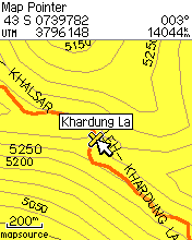
ROUTE OVERVIEW Manali - Leh The classic Himalayan ride. 475km of mountains, glaciers and 5,000m passes - all you'd expect from the second highest road in the world. Begins in Himachal Pradesh, ends in the ancient mountain kingdom of Ladakh - threshold of Tibet, China and Central Asia. Takes 8-10 days. With optional side routes to Pangong Tso, Nubra Valley, Tso Moriri and Tso Kar. Spiti & Kinnaur Even more remote than the Manali-Leh Highway, the valleys of Spiti and Lahaul have only recently opened up to foreigners. This 1,000km loop starts in Manali, heads east to Tibet then loops west again along the old Hindustan-Tibet Highway. Plenty of side valleys and rock hopping to keep you amused. Takes up to 4 weeks. Leh - Khardung La The highest road pass in the world at an extraordinary 5,602m. India would have you believe this is the highest road in the world, although Bolivia might disagree. Khardung La is the pass from the Indus Valley to the lush Nubra Valley, and from it you can see over the Karakoram range, home of K2. Takes 1 day. Leh - Srinagar Once rivalling Manali - Leh as the classic ride of the Indian Himalaya. Excellent tarmac surface passing through a stunning landscape of pea-green glacial rivers, crumpled mountain sides the texture of a rhino hide and the wonderful gompas of Lamayuru, Alchi, Likkir and Basgo. Friendship Highway Starting in Lhasa and finishing in Kathmandu, two of the most exotic sounding cities in the Himalaya, this long ride rarely drops below 4000m, making it the highest route in the book.
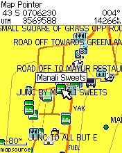
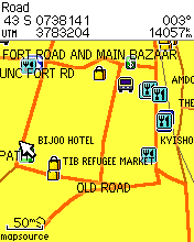
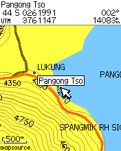
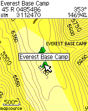
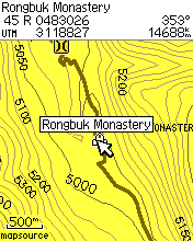
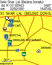
GPS IMAGES
IMPORTANT INFORMATION
International Borders have been added as
reference only and cannot be considered as precise nor actually stating the
current situation of Country limits. Always check the the border situation prior
to your voyage.
The auto routing feature is available for
all the city streets contained in this map. Nevertheless, due to the complexity
of the urban environment, we have not yet finished integrating all the traffic
related information such as oneways, physical and regulatory turn
restrictions. We are continuously incorporating such features which will
be made available through updates. This map shall always be used as a
complement for navigation and always be aware of actual street and road
traffic. RETURN POLICY No returns are accepted once the unlock key has been issued. No returns are accepted on CDs and openned preloaded cards. UPDATES We have the following update policies Yearly Updates We release a yearly version of the map identified by the year of issue. A new yearly version adds data that was not available in previous versions of the map and thus implies an upgrade fee for registered users. The upgrade fee will be announced at the time of release of a new yearly version. Updates During the Model Year All updates during the life of the model year will be for free for registered users. The installation and/or use of this map is considered as the acceptance of the terms exposed above. If you are not in agreement with them, DO NOT INSTALL THIS MAP. DELIVERY Two delivery options are available:
COMPATIBILITY AND INSTALLATION REQUIREMENTS This map is compatible with Garmin mapping GPS devices. Requires the PC based Garmin Mapsource program to be unlocked and installed. NOT COMPATIBLE WITH THE MAC PLATFORM. If you have a Mac, please contact us for alternatives. PRICE AND LICENSING The price is USD $ 100.00 and grants a single non transferable license to be used in one GPS device.
PURCHASE NOTE: Upon placing your order, your map will be delivered within 24 to 48 hours, Monday through Friday. Orders received on weekends will be processed next Monday.
Garmin™ y Mapsource are registered trademarks of Garmin Inc. and/or its affiliates
|