 |
Tus Propios Mapas para GPS Garmin Custom Maps for Garmin GPS |
|
Español La idea de tener mapas en tu GPS con el nivel de información y detalle que se ajusten a tus necesidades suena muy atractiva. Como hemos explicado en el estudio comparativo de mapas para GPS, lo que ofrecen los fabricantes como Garmin, Magellan y Lowrance tienen muy poco detalle para México y además la exactitud de la información deja mucho que desear. Afortunadamente varias personas y grupos de usuarios de GPS han dedicado tiempo a desarrollar programas que, sin afectar los derechos de autor de las distintas marcas, puedas crear tus propios mapas y subirlos a tu GPS de manera que satisfagan tus necesidades. Y además son gratis. y disponibles en Internet. Estos programas, por ahora, solo funcionan con equipos Garmin que tengan capacidad de desplegar mapas. Y el resultado es excelente como podrás observar en las siguientes imágenes. Para usuarios de equipos GlobalMap de Lowrance, con el software MapCreate versión 4 y un módulo especial de Oziexplorer se pueden crear mapas personalizados para estos modelos. Desafortunadamente para los modelos recientes, como el iFinder, que solo acepta MapCreate versión 5, esta ya no es una opción. Para Magellan, hay ya un grupo trabajando en desarrollar software que permita crear tus propios mapas. El avance que llevan es significativo, pero aún tendremos que esperar unos meses para tener un producto funcional. Las imágenes siguientes corresponden a la ruta El Mapa Valle de Bravo que recientemente publicamos con el que podrás hacer una comparación detallada.
|
English The idea of having maps in your GPS receiver with the detail level and amount of information that you need is a very attractive idea. As we have explained in the study comparing the offerings of Garmin, Magellan and Lowrance for Mexico, the amount of information and detail they have is very lacking. Fortunately, GPS users who happen to be very skilled in programming, have developed software applications that allow you to create your own custom maps and upload them to your receiver without affecting the Copyrights of the GPS makers. They are all freeware available on the Internet. For now this applications work only in Garmin mapping GPS uinits. And the results are excelent as you will in the following images. For Lowrance GlobalMap units users, custom maps can be made with MapCreate version 4 and a special Oziexplorer module developed for this purpose. Unfortunatelly it will not work with the recent iFinder units. For Magellan, a group of programmers is already working in the development of a software apllication that would allow to create custom maps. Progress has been significant but we will still have to wait a few months before a functional product is available.
The following images correspond to the route El Mapa Valle de Bravo which we published recently. With is you will be able to make a detailed comparison. |
|
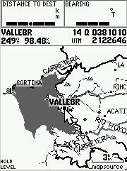
Este es el mapa de base del receptor Garmin GPS Map 76S en la zona de Valle de Bravo, que no aparece en él. Para hacer la comparación creamos el waypoint VALLEBR correspondiente al kiosco en el centro, que se ve en medio de la pantalla. |
|
This is the Garmin GPSMap 76S base map on the zone where we made the custom map. The city of Valle de Bravo does not show. We created the VALLEBR waypoint which represents the downtown area. |
|
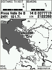
Al incrementar el nivel de zoom a 3 Km. empiezan a aparecer los detalles del mapa que creamos. Puedes ver la presa, carreteras, algunas veredas y poblaciones pequeñas. |
 |
As we increase the zoom level to 3 Km. the details of the custom map start to show. You can see the town layout, the dam, highways, some fireroads and trails as well small towns. |
|
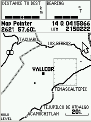
Zoom a 2 Km. en el que ya podemos ver las calles de Valle de Bravo y Avándaro. |
 |
At a zoom of 2 Km. the streets layout starts to show for both Valle de Bravo and neigthboring Avandaro. |
|
Zoom a 500 m. donde vemos el detalle de las calles de Valle de Bravo. Es posible poner el nombre de cada calle individual, aunque en este caso no lo hicimos así. |
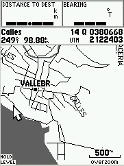 |
Zoom at 500 m. shows street detail at Valle de Bravo. It would be possible to name each street, but we did not do that in this case. |
|
Zoom a 200 m. para ver el trzado de las calles en el centro de Valle de Bravo. |
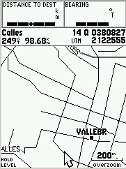 |
Zoom at 200 m. shows detailed streets at Valle de Bravo's downtown area. |
|
Esta es una imagen de la laguna de Capilla Vieja en la misma ruta, a la que añadimos las curvas de nivel de la escala 1:250,000 del mapa del INEGI. |
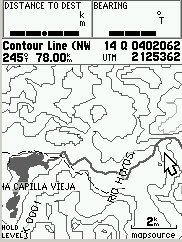 |
This is the image of the Capilla Vieja lake on the same route. Contour lines from the 1:250,000 scale INEGI map were added. |
|
El menú que te permite seleccionar que mapas detallados deseas ver. |
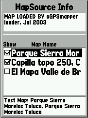 |
The GPS map menu showing tha available loaded maps. You can choose which ones to display. |
|
Información Adicional |
Additional information |
| Los 3 archivos que se muestran en el GPS ocupan un total de 35 Kb. El GPSMap 76S tiene 24 Mb de memoria para mapas. El proceso de creación no es muy rápido y requiere de mucha intervención de la persona que lo está haciendo. La información se encuentra en diferentes sitios de Internet por lo que no existe un manual que te lleve paso a paso en todas las etapas del proceso. Por ello para aprender a hacerlos es necesario investigar, preguntar y hacer muchas pruebas. Las aplicaciones usadas para crear los mapas evolucionan constantemente y puedes encontrar actualizaciones continuamente.
|
The 3 map files shown on the GPS screen use 35 Kb of memory. The GPSMap 76S has 24 Mb available for maps. The map creation process is not fast and requires a lot of input from the person who is making it. The information to make them is available at several different Internet sites and no manual is available. So, in order to learn how to create the maps it is necessary to investigate, ask questions and a lot of trial and error. The applications used to create the maps evolve and are updated continuously. |
|
Para hacer estos mapas usamos MapEdit y cGpsmapper. Los enlaces a los sitios donde encuentras están a continuación. También hay enlaces a otros sitios con software similar, como Mapdekode. |
We used MapEdit and CGpsmapper. The links are shown below. We also provide links to Mapdekode and other related sites. |
| MapEdit http://kgy.narod.ru/util/mapedit/mapedit_e.htm cGpsmapper & sendmap http://gps.chrisb.org/gps_mapper.htm Mapdekode http://planeta.terra.com.br/informatica/download1/dekode_contract.htm GPS Trackmaker Tutoriales e información sobre mapas personales Custom Map cretion tutorials and info http://vip.hyperusa.com/~dougs/
|
|
|
Artículos sobre creación de mapas (en español e inglés) |
Articles about creating maps (In English and Spanish) |
| http://www.elgps.com/documentos/consejos/EnviarDatosMapsource.html http://www.elgps.com/documentos/comparativa/76S/Pantallas76S.html http://www.elgps.com/documentos/MapasPropios/MapasPropios.html http://www.gpsinformation.org/adamnewham/article1/gpsmapper.htm
|
|