 |
Tus Propios Mapas para GPS Magellan Custom Maps for Magellan GPS |
|
Español Después de varios meses de investigación, participación en foros, aprendizaje y muchas pruebas, por fin sabemos como crear tus propios mapas para GPS Magellan. Thales Navigation, propietarios de Magellan, lanzaron al mercado un producto para uso profesional llamado Mobile Mapper Suite, que consta de un receptor de GPS muy parecido a un Magellan Meridian Color y un software para aplicaciones GIS (Geographic Information Systems). El software, llamado Mobile Mapper Office (MMO) tiene una opción llamada Background Map que se usa para subir mapas al receptor GPS. Por pura casualidad alguien probó esta opción con los GPS Magellan y resulta que son compatibles y se pueden crear estos mapas. A manera de introducción, aquí te presentamos algunos de los ejemplos de las pruebas hechas hasta ahora. Pronto daremos más detalles.
|
English After several months of learning, research, participation in internet groups and a lot of testing, we finally know how to create custom maps for Magellan GPS receivers. Thales Navigation, Magellan owners, launched Mobile Mapper Suite, a product targeted to the professional user. This product has 2 components: a GPS receiver which looks very much like a Magellan Meridian Color and a software known as Mobile Mapper Office. The software, among other applications can create "Backgroung Maps" that can be uploaded to the receiver. Someone tried this application with Magellan receivers and turned out that they are compatible and can be used to upload custom maps to Magellan GPS receivers. As an introduction, here we present a few samples of what we have been able to do so far. We will publish more information shortly.
|
|
|
|
||
|
El mapa como se ve en la pantalla del software Mobile Mapper Office (MMO). Para crearlo se usa una opción llamada “Background Map”. Los archivos de puntos líneas y polígonos que usé para crear el mapa de Garmin se transformaron al formato ESRI SHP que requiere MMO.
|
The map as it shows on the PC screen using Mobile Mapper Office using the Background Map option. These are the same raw information files used for Garmin Custom Maps. |
||
|
|
|
||
|
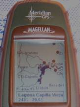
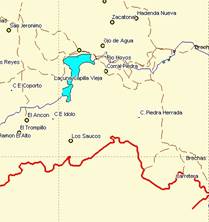
El GPS Meridian mostrando la zona del mapa de detalle sobre el mapa de base. Las curvas de nivel son las del mapa de base. No fueron creadas por mí. |
The Meridian GPS showing the custom map on top of the World Wide Base Map. |
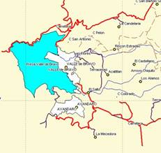
Aquí vemos como se combinan unas características personalizadas con el mapa de fondo. Esto fue una sorpresa ya que normalmente los mapas detallados no se combinan con los de fondo. |
Here we see how the custom map merges with the basemap. |
|
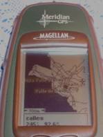
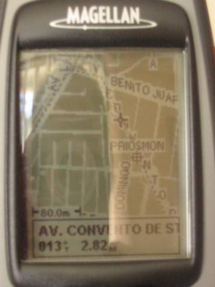
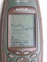
Aquí vemos la comparación del mapa como se ve en el software comparado como se ve en la pantalla del GPS |
Here we see how the map shows on the GPS screen compared to the PC screen. |
|
|
|
|
|
|
|
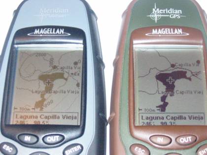
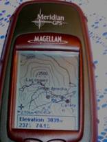
Imagen del GPS después de editar la apariencia de los diferentes objetos. El Meridian Platinum muestra el mapa editado y el Verde muestra el mapa tal y como sale de MMO.
|
GPS screen shots showing the maps after editing the objects appeareance. The Platinum shows the edited map and the Green shows the image as it is created by MMO |
|
|
|
|
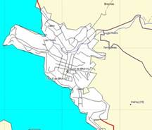
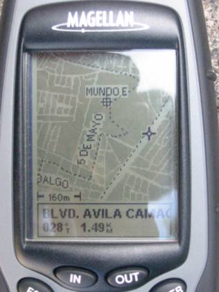
Usando la base de datos vectoriales de INEGI, se pueden crear mapas detallados de calles. Este es un ejemplo de la zona noroeste de la Cd. de México. La línea punteada es el track marcado por el GPS al recorrer las calles, lo que confirma la precisión de la información de INEGI
|
Using INEGI Vector information data bases, detailes street maps can be created. This is a sample of northwest Mexico City. The dotted line is the track created by the GPS as we drove those streets. This confirms the accuracy of INEGI's databases. |
|
|
|