El Cartógrafo
Mapas de México para GPS
The Cartographer
Mexico GPS Maps
|
Bienvenido a El Cartógrafo, la sección de BiciMapas que te ayudará a poner a México en tu GPS.
Aquí encontrarás mapas que puedes subir a tu GPS, ya sea Garmin o Magellan, para que los puedas usar junto con las rutas de MTB publicadas. Los programas comerciales de mapas tanto de Garmin como de Magellan no los tienen disponibles con suficiente nivel de detalle para México, como puedes ver en el análisis Comparativo de Mapas GPS. Después de varios meses de estudiar las alternativas para crear Mapas para Garmin y Mapas para Magellan estamos listos para poner a tu disponibilidad una serie de mapas de México que hemos creado con información más completa y detallada que los hacen más prácticos para su uso en nuestro país. Además están pensados para ser usados en conjunto con los archivos de tracks y waypoints de las rutas de BiciMapas. Así que salir a conocer los senderos de México en MTB, es ahora aún más atractivo con la ayuda de la tecnología pero sin perder el espíritu de aventura. Ve estos artículos relacionados con cada marca:
|
Welcome to The Cartographer, the BiciMapas section that will help you to put Mexico in your GPS.
Here you will find maps that can be uploaded to your GPS, whether Garmin or Magellan, so that they can be used all together with the MTB published in our site. As already it is known, the commercial programs of maps from Garmin as well as Magellan do not have maps available with sufficient level of detail for Mexico, as you can see in the Comparative analysis of GPS Maps. After several months of learning and testing the methods available to create custom Maps for Garmin and Maps for Magellan receivers, we are ready to put in your hands a series of maps of Mexico that we have created with more detail and information completeness. In addition they were developed to be used together with the waypoint and track files published in BiciMapas. So it is now more attractive to explore the mountain bike trails in Mexico with using a little help from technology without loosing the spirit of adventure.
|
|
Acerca de los archivos de Mapas Los mapas para GPS se proporcionan en los siguientes formatos: IMG de Garmin.
|
The GPS maps are provided in the following formats:
Garmin IMG.
|
|
Mapa para Magellan como se ve en MMO Magellan Map as seen in MMO
|
Mapa para Garmin como se ve en GPSMapEdit Garmin Map as seen in GPSMapedit |
|
NOTA: Aunque ambos formatos tienen las extensión IMG, no son compatibles entre marcas. Un archivo IMG de Garmin no es reconocido por un GPS Magellan y viceversa. Para distinguirlos hemos usado la siguiente nomenclatura: Los mapas para Garmin tienen una letra “G” al final del nombre del archivo, por ejemplo “ChilucaG”. Los mapas en formato de Magellan tienen una “M” quedando por ejemplo “ChilucaM”. Además en caso de haber la opción de mapa topográfico o plano (sin curvas de nivel). En este caso a los topográficos se les agregará una “T” quedando “ChilucaGT” para mapas topográficos en formato Garmin o “ChilucaMT” para topográficos en formato Magellan. |
NOTES: Although both formats have the IMG extension, they are not compatible among both brands. An IMG file from Garmin is not recognized by a Magellan GPS and vice versa. To distinguish among them we have used the following codes: The maps for Garmin have a letter “G” at the end of the file name, for example “ChilucaG”. The maps in Magellan format have an “M” for example “ChilucaM”. Besides there might be the case of having topographical or flat map (without contours) option. In this case the topographical map will have a “T” at the end of the file. So, “ChilucaGT” for topographical map in format Garmin and “ChilucaMT” for topographical in Magellan format.
|
Algunas fuentes de Información para crear los mapas
Bases de datos de acceso libre
Hay varias fuentes en Internet que ofrecen información de manera gratuita y sin restricciones de uso salvo mencionar los créditos. En algunos casos la información se usó tal y como se obtiene de los sitios pero en otros tuvo que ser adecuada y modificada.
|
Some information sources used to create the maps
Free access data bases
Several Internet sources offer free downloadable information suitable to map creation and without usage restrictions other than providing the respective credits. In some cases the information may be used as is but in others it has to be processed. |
| ESRI WORLD BASEMAP | http://www.esri.com/data/download/basemap/ |
| SRTM | http://edcftp.cr.usgs.gov/pub/data/srtm/ |
| GEONET NAMES SERVER | http://earth-info.nga.mil/gns/html/cntry_files.html |
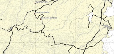
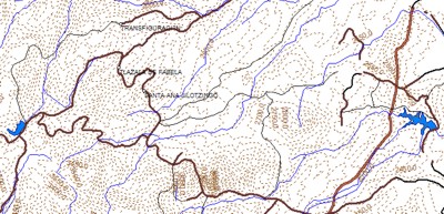
Tracks y waypoints de la base de rutas de BicimapasAlgunos de los mapas incluyen puntos de referencia y veredas que se han marcado con el GPS tomados de la base de rutas y waypoints publicados en las diferentes rutas de Bicimapas. Creación manual de geometríasEn algunos casos hemos creado manualmente las geometrías incluidas en algunos mapas para agregar características que no se encuentran en las fuentes anteriores. Información Vectorial del INEGIEl INEGI cuenta con una base de datos vectoriales y de topónimos muy detallada de todo el país, pero esta debe ser adquirida. Esta información es mucho más completa, exacta y detallada que la que se encuentra disponible gratuitamente en Internet por lo que podrás crear mapas con un altísimo grado de detalle. Esta es una comparación entre un mapa creado con información de INEGI y uno con información gratis de internet. Si te interesa adquirir la información de INEGI para crear estos mapas, visita nuestra Tienda de Mapas para darte más detalles.
|
The Bicimapas Track and waypoints files Some of the maps include reference points and trails from the routes that have been pubished in the site, based on our GPS trail mapping process. Hand made geometries In several cases we have manually created some features, which are not available in the other sources, to be included in the maps and add custom detail. INEGI Vectorial Information INEGI has a very detailed and complete vectorial information data base for the whole country but it shall be acquired. Obviously this data base is much more complete, detailed and accurate than the one available for free in the Internet. Below you can see a comparison among INEGI's data and ESRI's World Map data. If you are interested in purchasing vectorial information from INEGI data bases, please contact us to provide more information. |
|
Mapa basado en información de INEGI Map created with INEGI information |
Mapa creado con información de ESRI World BaseMap Map created with ESRI World BaseMap information |
Como subir tus mapas al GPSLos métodos descritos a continuación son con aplicaciones freeware así que su uso es bajo tu responsabilidad y los términos en que cada autor las ha publicado.
Instrucciones para Garmin |
How to upload the maps The methods described below are based on freeware applications used at your own risk and in the terms used by their authors.
|
||||||
|
|
|||||||
|
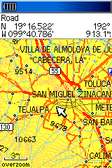
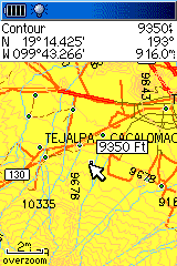
Así se ven Si tienes un GPS Garmin con pantalla a colores, los mapas se ven como se muestra en estos ejemplos (Cortesía de Doug Smith)
|
This is how the look If you have a color screen Garmin GPS, the maps will show as seen in this examples (courtesy of Doug Smith) |
||||||
|
|
|
|
|||||
|
|
|||||||
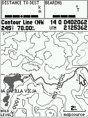
Los MapasEn la siguiente tabla encontrarás los mapas y respectivos enlaces para descargarlos en tu PC. La imagen de ejemplo está tomada de una captura de la pantalla de mi Garmin GPSMAP 76S. Antes de usarlos por favor lee este mensaje importante con atención. |
The Maps Following you will find the links to download the maps. The sample image is a capture taken from a Garmin GPSMAP 76S receiver. Before downloading and using these maps please read this very important information. |
||||||
Ve nuestro mapa de Carreteras de México See our Mexico Road Maps
| Mapa/Map |
Magellan Para Modelos Meridian y Sportrak, NO compatibles con Explorist For Meridians and Sportraks, NOT compatible with Explorist. (Meridian, Sportrak and Explorist are trademaks of Thales or its subsidiaries) |
Garmin Nota: Estos mapas deben ser subidos al GPS con Sendmap a menos que se indique de otra manera Note: These maps shall be uploaded with Sendmap unless otherwise indicated |
Imagen ejemplo/Screen shot |
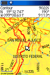
| Ajusco | AjuscoMT | AjuscoGT | 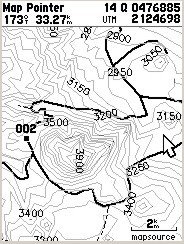 |
| Chiluca | ChilucaMT | ChilucaGT | 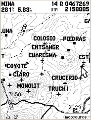 |
| Puebla | PueblaMT | PueblaGT | 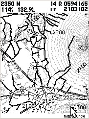 |
| Toluca | TolucaMT | TolucaGT | 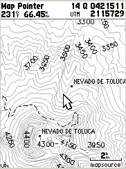 |
| El Mapa a Valle de Bravo | MapaVBraMT | MapaVBraGT |
 |
| Bosque
de la Primavera Cortesía de Luis Casillas |
PrimaM | PrimavG |
 |
| Lago de Zirahuén, Michoacán por Irak Pérez | ZirahuenM | ZirahuenG | |
| Todas las rutas de BiciMapas publicadas hasta Diciembre 2004 All BiciMapas MTB trails published to December 2004 |
BiciMapasM |
BiciMapasG Con este mapa estrenamos nuevo instalador para Mapsource. With this map we start using our new installer
|
|
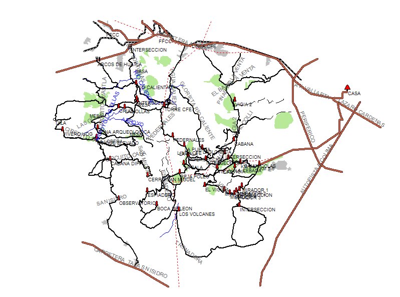
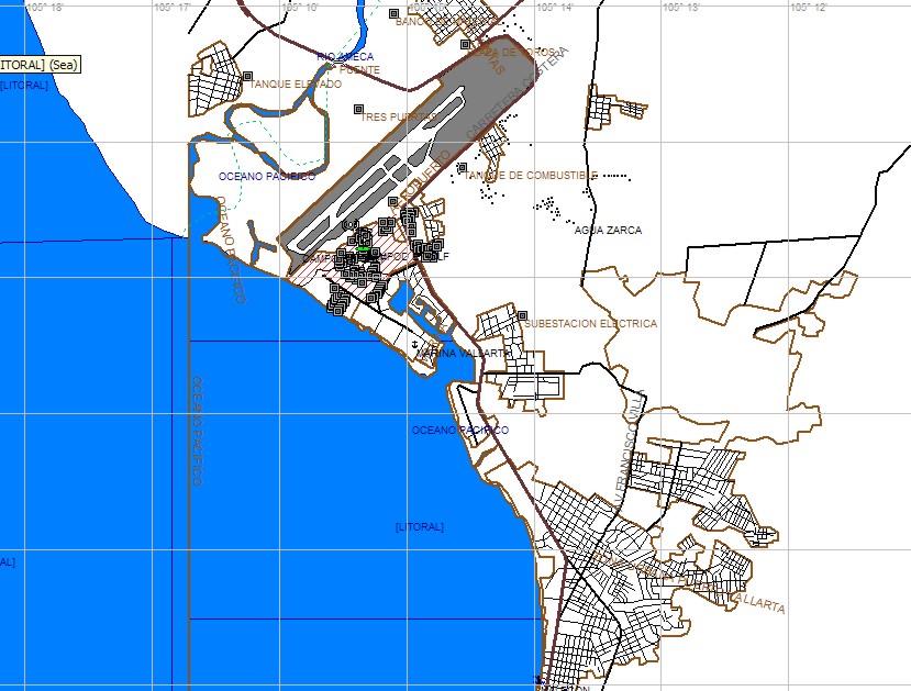
| Puerto Vallarta por Mauricio Lozano |
No Disponible aún | PtoVallartaG |
 |
|
Gran Chiluca Mapa topográfico equivalente a los mapas E14A28 y E14A29 |
En versiones para Meridian o Explorist (2.8 Mb) |
Gran Chiluca para Garmin Archivo de 3.5 Mb |